
Visualise levies and their projects
Make the connection visible between where development levies are collected and the projects they fund, with filters to view projects by service category, contributing catchment or delivery status.
Dynamically visualise and communicate development levies and their contributing projects. Openflow connects Councils delivering infrastructure with the land developers who rely on it, through a standardised map-based platform for sharing key project details, gathering growth insights and providing transparency across an evolving infrastructure landscape.
A standardised platform that connects development levies to the projects they fund — giving councils and communities a clear and current picture.
Make the connection visible between where development levies are collected and the projects they fund, with filters to view projects by service category, contributing catchment or delivery status.
Offer developers a standardised tool to estimate development levies for any site, anywhere - even where levy areas overlap between neighbouring districts.

OpenFlow stays aligned with the record-keeping and reporting requirements of development levy regulation as they evolve, so your team can focus on local knowledge and decision-making, not platform development.
Gain visibility into developer interest across specific projects and levy areas, through a standardised channel for sharing growth intentions that can directly inform infrastructure sequencing.
Answers to the key questions councils and CCOs have about how OpenFlow works, where it's headed, and how to get involved in the closed pilot program.
OpenFlow is a shared, map-based platform for managing infrastructure projects. It helps visualise projects, communicate plans to address them, and support open collaboration with the development community.
OpenFlow supports the intent of Local Water Done Well by strengthening transparency and communication across the sector. It helps councils and CCOs share network information, highlight projects, and make capacity data more visible to the public—building a clearer, more accountable picture of local infrastructure.
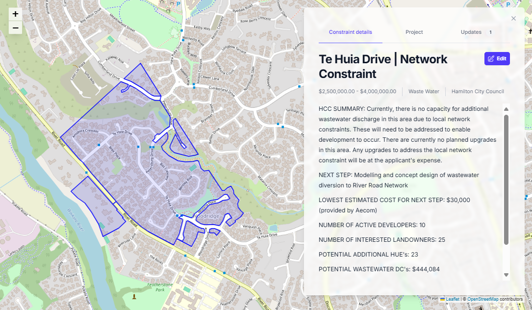
A shape represents the approximate extent of properties that will realise the most benefit from a particular infrastructure project. In cases where the project resolves a known constraint that is impacting development, the spatial extent will probably align closely with the constrained extents.
OpenFlow is currently in its early access phase. The core communication and coordination features are complete and being refined with input from pilot councils and CCOs.
OpenFlow stores project metadata, known projects, communication logs, and engagement records. It is not a GIS replacement but complements existing GIS datasets by adding collaboration and compliance layers.
OpenFlow connects through standard spatial data formats. Projects and project layers can be imported or exported to maintain consistency with local GIS environments.
Access is role-based. Councils, CCOs, asset owners, and the development community can all participate within defined permissions. Each organisation controls what information it shares, while developers gain visibility into projects and capacity to inform better project planning.
Water services providers and members of the development community can register for the waitlist to be notified as early access expands. Selected organisations and developers will be invited to participate in the closed pilot before the full release.
The transition to Local Water Done Well is still taking shape, and many organisations are defining how they'll operate. Joining the OpenFlow pilot early allows your future water services provider to shape the platform around your specific structure, workflows, and engagement approach—so it's ready to go live when you are.
Pilot participants will use OpenFlow in live coordination settings, provide structured feedback on usability and data workflows, and help shape integration options for regulatory reporting. Participants receive ongoing support and early adoption advantages before the public rollout.